
Cauvery…. The name is closely associated to TamilNadu politics for almost three decades. Every political party in Tamil Nadu and Karnataka are making a big issue about sharing cauvery river water. The Supreme court for its role has been giving verdict after verdict for sharing cauvery water between these two states nay five states… Including Pondicherry, Kerala and Andhrapradesh. But in all these political heat one thing is conveniently forgotten by all the political parties.
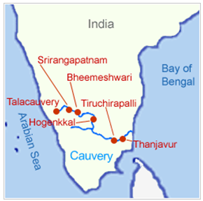
The river enters Tamil Nadu through Dharmapuri district leading to the flat plains where it meanders. It drops into the Hogenakkal Falls just before it arrives in the town of Hogenakkal in Tamil Nadu. The three minor tributaries, Palar, Chinnar and Thoppar enter into the Kaveri on her course, above Stanley Reservoir in Mettur, where the dam has been constructed. It then flows further through the length of Erode district where the river Bhavani, running through the breadth of the district, merges with it. The confluence of the rivers Kaveri, Bhavani and Akash Ganga (mythological) is at the exact place of Bhavani, Tamil Nadu Kooduthurai or Tiriveni Sangamam, Northern part of Erode City.
While passing through Erode, two more tributaries merge. Thirumani Mutharu joins it in a village called Kududurai in Namakkal District. Noyyal and Amaravathi join it in Karur district before it reaches Tiruchirapalli district. Here the river becomes wide, with a sandy bed, and flows in an eastern direction until it splits into two at upper Anicut about 14 kilometres (9 mi) west of Tiruchirappalli. The northern branch of the river is called the Kollidam while the southern branch retains the name Kaveri and then goes directly eastwards into Thanjavur District. These two rivers join again and form the Srirangam island that is a part of the city of Tiruchirapalli. The fourth oldest functional dam[8]Grand Anicut or Kallanai was present at this place. From Thanjavur, the river splits and goes to few places in the Delta Kaveri.
Cauvery tributaries – Rivers originating in Tamil Nadu and merging with cauvery river. No farmers associations which are politically affiliated raise their voice for this genuine cause. Unfortunately no steps has been taken by any ruling governments to preserve and safeguard the catchment areas of these rivers origin.
Amaravathi River: Amaravati River is a tributary of Kaveri River in Coimbatore. It is continuation of the Pambar and Chinnar rivers in Kerala. It begins at Manjampatti Valley between the Annamalai Hills and the Palni Hills in Indira Gandhi Wildlife Sanctuary and National Park. It descends in a northerly direction through Amaravathi Reservoir and Amaravathi Dam at Amaravathinagar. It is joined by the Kallapuram River at the mouth of the Ajanda valley in Udumalaipettai. It joins with the Kaveri at Thirumukkudal, about 10km from Karur.
Bhavani River: Its a major tributary of Cauvery River. It originates in Nilgiri Hills, where 12 major rivulets join Bhavani. The west and East Varagar tributaries coming from the Nilgiris are the largest and each have dams in Tamil Nadu. The Bhavani is a 217 km. long perennial river fed mostly by the southwest monsoon and supplemented by the northeast monsoon. Its watershed drains an area of 6,200 km² spread over Tamil Nadu (87%), Kerala (9%) and Karnataka (4%).
The water shed drains of Bhavani needs to be protected which is nearly 5000 km2 in TamilNadu and the steps taken for protecting this entire stretch needs to be taken on top priority.
Noyyal River:
The Noyyal River is a small river in Western Tamil Nadu, and a tributary of Kaveri River. It rises from the Vellingiri hills in the Western Ghats in Tamil Nadu, very close to Kerala border, and flows through many villages and the cities of Coimbatore, Tirupur and Erode, finally draining into the Kaveri River at Noyyal, a village near Kodumudi in Erode district named after the river itself. The river’s basin is 180 km (110 mi) long and 25 km (16 mi) wide and covers a total area of 3,500 km2 (1,400 sq mi). Cultivated land in the basin amounts to 1,800 km2 (690 sq mi) while the population density is 120 people per km² (311/mi²) in the countryside, and 1000 people per km² (2590/mi²) in the cities. The area is known for its scanty rainfall and the development of the Noyyal River Tanks System to hold any overflow from the rains plus the water of the Northeast and Southwest monsoon season was ecologically important. The 173 km (107 mi) long tributary of the Kaveri River]filled 32 tanks.
Pollution of Noyyal River:
A critical issue is the pollution of the rivers Noyyal and Nallaru originating and flowing in the Kongu region. The river flows with natural antibiotic minerals. The entire Orathuppalayam Dam has become a tank holding effluent and releases water after every rainfall, effectively polluting the down river villages in the Tirupur and Karur district.
However, from 2004 onwards, efforts by local volunteers organization Siruthuli have been trying to conserve the water resource. After several petitions from 2003 to 2011, dying and bleaching units were ordered closed on the river until zero liquid discharge status was achieved.
The Cheyyar River and the Kanchimanadhi are the tributaries to the river. They all have their origins in the Western Ghats. Periar flows out of the Siruvani hills and the Kovai Kutralam, a landmark waterfalls. Chaadiaar or Cheyyar River flows through Chaadivayal and later along with the other rivers join up at Kooduthurai to become Noyyal River.
After running through a distance of 180 km (110 mi), Noyyal joins with river Cauvery near Kodumudi, the place is also called Noyyal, Karur District. Apart from these three rivers, there are numerous rivulets that also join Noyyal. But most of these rivulets carry water only during the rainy season and therefore are not perennial. According to the available sources, the number of rivulets are 34.
Conclusion:
There is no use in depending on the political forces in Tamil Nadu for getting a permanent solution for cauvery water dispute. Only the common man and “Real”farmers who actually do farming can bring in solutions for this . Let us try to preserve the catchment areas of Tributaries of cauvery rivers in Tamil Nadu.
